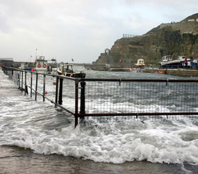
The cyclone that brought about the devastating winds that battered the UK in the great storm of October 1987 was exceptional in both its strength and path across the south of the country.
This is the finding of a new study which has analysed the places where sting jets—an area that develops in some cyclones and causes strong surface winds—appear in the North Atlantic and how often they do so.
Presenting their results today, Friday 11 May, in IOP Publishing’s journal Environmental Research Letters, researchers from the University of Reading and Monash University, Australia, studied the hundred most intense storms to have occurred across the North Atlantic in the past twenty years.
Of the 100 storms studied, they found that around 30 per cent of the storms had the potential to produce sting jets but these seemed to originate in relatively warmer, more southerly latitudes, out at sea.
A sting jet originates in a cyclone at an altitude of five kilometres within layers of moist ascending air. As the jet of air descends, it passes through clouds of ice crystals that cool it down, increasing its density and causing it to accelerate to speeds of up to 100 mph.
These strong winds appear in regions of a cyclone where they would not usually occur according to previous models.
“This descending jet is called a sting jet due to its location at the tip of the cloud head that wraps around the storm centre. This cloud resembles a scorpion’s tail because of its hooked shape and is therefore described as the sting at the end of the scorpion’s tail,” said lead author of the study Dr Oscar Martínez–Alvarado.
The research shows that sting jets are a common feature of the most intense North Atlantic storms and that the potential impact of these storms crossing heavily populated areas should be considered by the insurance industry, policy makers and engineers who rely on these types of scientific advances to assess risk.
The time period analysed in this study was between 1989 and 2009; however, the researchers have highlighted two recent storms that struck Scotland in December last year and January this year, which both showed signs of a characteristic sting jet and produced winds of over 100 mph, leaving thousands of people without power.
“There is no evidence to suggest that sting jet storms are becoming more frequent. It really remains a question of chance.
“Using a technique similar to the one we used here, it would be possible to see signs of the potential for sting jets some six hours in advance. However, their time and length scales are so small that forecasting their actual occurrence remains a very difficult task,” continued Dr Martínez–Alvarado.